Development plan is a medium term comprehensive plan of spatio-economic development of the urban centre.
Revised Development plan for Rajkot shall indicate the manner in which the use of land in the area covered by it shall be regulated and the manner in which the development therein shall be carried out.
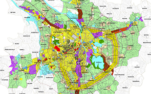
The Draft Revised Development Plan is to be prepared considering various demands of projected population for the next 10 years of the entire urban development area. The existing land use, circulation pattern, development potentiality of the land etc., are to be considered while deciding future proposals. Proper distribution of the residential, industrial, commercial zone, as well as open and recreational spaces is to be suggested to evolve overall urban form for entire RUDA area for the year 2031.
The Second Revised Draft Development Plan, 2031 is prepared considering the demand of projected population of next two decades for the entire area of 686 sq. km. of Rajkot Urban Development Authority (RUDA). This total area consists of Rajkot Municipal Corporation (RMC) Area, 54 (52*) villages under RUDA. (* As Kotharia and Vavdi are recently added in RMC Boundary)
The current city form of Rajkot has been shaped by the existing zoning development regulations and the “rings & radials” street network which has been evolved over past decades. This street network has shaped the nature and form of development that has taken place within the city. The general development pattern in the city has followed typical density patterns with concentration of highest density in the central areas, gradually reducing towards the periphery. The existing zoning and development regulations have resulted in a relatively moderate density and primarily low rise urban form with scattered sprawl on outer fringes.
The urban framework in the Second Revised Development Plan 2031 aims to build upon the vision and the principles to guide the urban form of the city so that development continues and urban infrastructure is optimized. Increase in density is proposed through introduction of telescopic FSI and transit oriented zones which can help facilitate densification and redevelopment in existing areas.
Higher densities are proposed along public transport corridors to facilitate transport, reduce congestion, reduce dependability on private transport and optimize investments in transport infrastructure. This will help define characters of the different neighborhoods, thereby improving and enhancing the image and legibility of the city.
The proposals and recommendations form the main core of this Second Revised Draft Comprehensive Development Plan 2031. They are formulated after multiple deliberations, detailed analysis of existing conditions, future growth projections, the overarching vision, the principles and the input from stakeholders all combined. Even though many of these proposals cover more than one focus area, for ease of organizing they are grouped under nine subsections which are as follows
Generally, proposals are the proposed tasks that are to be carried out or implemented primarily by the Authority, Whereas recommendations include the ‘tasks’ or actions for which other government departments or entities may have to take primary role, with the authority supporting them.
Rajkot Urban Development Authority,
Shri Chimanbhai Patel Vikas Bhavan,
Post Box No.238, Jamnagar Road, Rajkot Gujarat, India.